

This is part of my Photo Location Guide series. To see them all, visit this page.

The west side of Olympic National Park is where you go for the rain forests and the beaches. If you're going to concentrate on those, then you're better off finding a place to stay on the west side rather than staying in Port Angeles.
Forks has several motels, a grocery store, and plenty of places to eat and is probably the best place from which to base yourself. La Push, on the coast, has a couple of places, including cabins on the beach. Camping is available in the National Park at the Mora campground near Rialto Beach and Bogachiel State Park, south of Forks.
Another option is the Kalaloch lodge south of Ruby Beach. This National Park lodge is right on the beach and can be a good location if you want to also explore the Quinault area.
I'll be referring to several locations in a pretty far flung area so it might help to keep up if you have an Olympic National Park map.
If you're planning on getting out on these beaches, be aware that these are wilderness beach areas with large pieces of driftwood that can trip you up, and tides that can trap you on the wrong side of a headland.
Be sure you've got a tide table. You can pick one up at just about any gas station or store in Forks. Or get a tide app for your smart phone. Just be careful on the beaches!
The Beaches
Closest to Forks are Rialto Beach, First Beach and Second Beach.

From Forks, take Hwy 110 west and follow the signs. First and Second Beaches are along Hwy 110 near La Push and Rialto Beach is at the end of the Mora Road.
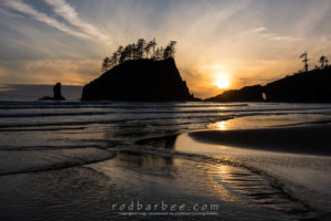
First Beach is in the town of La Push. Just drive out to the end of the town and look for a large gravel parking area just south of the main town area. It's on the left side of the lot. There's also a sea stack right in front of you and this is a good, easy place for a sunset.
Be sure to explore the town a bit. There's a small harbor and you should be able to find piles of nets and stacks of crab pots to photograph.
Second Beach
Second Beach is accessed by a 3/4 mile trail. The trailhead parking lot is located just before you get into the town of La Push. The trail is well maintained and is pretty easy. It's downhill to the beach and uphill back, though it's not difficult. You'll want good hiking boots though.
Second Beach can be good for sunrise or sunset. Either way, bring a headlamp for the walk, you'll likely be doing some of it in twilight.
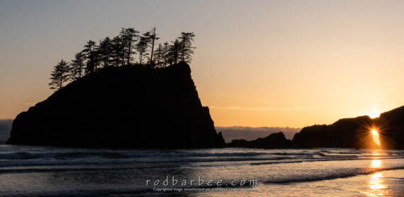
Early in the morning there can be fog. Around sunset you can use the sea stacks as silhouettes against a sunset sky.
In late spring to late summer, the sun sets north enough to photographing it coming through a hole in the headland.
Rialto Beach

Rialto Beach is probably the easiest accessed. Just park in the parking lot and follow the short, flat trail to the beach. In the fog, the spruce forest here can be ethereal.
Be sure to photograph from within the forest and looking back at the forest from the beach. On foggy days like this, think "Black & White."
Rialto is probably my favorite beach to go to. And not just because it's so easy to get to.

One of my favorite things to do here is photograph the colorful beach rocks. I'll wander around collecting the best I can find and then arrange them. I always have a water bottle with me to wet the rocks. This makes the colors really come through. You'll probably want to put your polarizer on for this.
About a mile and a half north on Rialto Beach is Hole-In-The-Wall. You'll find sea stacks, weirdly sculpted rocks, and tide pools. And tents (It's a popular camping area). Wear sturdy footwear.
At about the one-mile point you'll need to cross a small stream. There is often a log in place. Sometimes you'll need to get close to the shore and make your way across the shallow stream. Don't let this stop you though, it's easy to cross.

At the end of the beach is a headland. At low tide one can walk around the headland, but at high tide, hikers must take the rough and somewhat steep trail over the headland.
It's this trail that I want to point out. If you're up to it, scramble up this trail. Soon you'll see a side trail that follows the narrow top of the headland. From here you get a great view looking north. There's not much room to work here, maybe room for a couple of photographers who don't mind sharing a close space and trading places. Be careful where you set down your gear, there aren't a lot of flat spaces. A normal to short telephoto lens should do well from up here. If there are some great clouds you may want to go wider.

If you can get here late in the afternoon while the tide is starting to get high, you'll be rewarded with nice light on the surf surrounding the sea stack.
Don't worry about the hike back. Just make sure that the high tide isn't going to be incredibly high. In the summer there should be no worries and you'll have a relaxing walk back to the parking lot, photographing the sunset along the way.
Ruby Beach

Ruby Beach is about 40 minutes south of Forks and is a popular place to go for a sunset. An easy trail leads from the parking lot down to the beach. There are several sea stacks, lots of driftwood, and lots of options. Get there early enough to walk north along the beach to see some of the possibilities. After sunset, while walking the trail back up to your car, be sure to look back toward the ocean at the silhouettes of trees against a pink and blue sky.
Ruby Beach is also a fantastic location for Milky Way photography during the summer months. Be sure to consult PhotoPills or an astronomy app to find out the best nights for Milky Way photography. And a tide app or tide table to make sure you and your equipment don't take an unexpected bath.
If you do go be aware that because it's a marine environment and there's lots of moisture in the air, as the temperature drops at night there's a good chance of dew forming on your lens. For a solution to that, see this page.
South of Ruby Beach is Kalaloch. The lodge is a great place for lunch after a morning visit to the Hoh rain forest, by the way. There are no sea stacks on this beach, but it's full of shapely drift wood.
Shi Shi Beach is north of these other beaches. Way north.
This is one location I've not been to at all. And I'm not sure why, other than it takes a bit more planning. You see, you need to backpack to it. Well, you could go out there on a day hike, but it's a place for sunsets and you wouldn't want to be hiking out at night.
Plus it's just way the heck out there; a long drive on Hwy 112 to Neah Bay followed by, from all accounts, a reasonable hike. A Makah recreation pass, obtainable in Neah Bay is required. You'll also have to park in designated private parking lots.
But it will be worth it. Some of the most striking Olympic coast images I've seen have been made at Shi-Shi beach.
If you want to give Shi Shi a go, the National Park site has the information you need to know.
The Forests
The Hoh

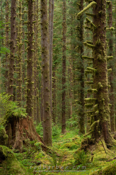
Probably the best time to visit the Hoh rain forest is in mid-May to mid-June or so. Once July comes along things start drying up and you get many more sunny days. In mid-May you stand a better chance of having overcast or rainy days and the ferns and maple leaves will be fresh and new and barely bug eaten.
The Upper Hoh Road is about 13 miles south of Forks. Before you even enter the park you may find some forest scenes worth shooting. But be sure drive to the end of the road. And keep your eye out for elk.

From the parking lot at the end of the Hoh road there is a well marked trail near the visitors center. This trail leads to a junction where you can walk to the Hall of Mosses loop trail, check out the Spruce Nature Trail, or start walking the 16 mile long Hoh River Trail.
Most photographers head for the Hall of Mosses trail. And if you've only got a short time to visit, I suggest you do the same.
On the way to The Hall of Mosses trail you'll cross Taft Creek, a beautiful crystal clear spring-fed stream. You can try photographing it, but I usually just look and enjoy.
The Hall of Mosses trail is a loop trail, and when you come to where the loop starts, go left and take the loop in a counterclockwise direction. You'll find photogenic forest right away.

If visiting in the summer, I suggest getting here early in the day (by 7 a.m. or so) to avoid crowds. I'd also suggest bypassing the first scenes you see and just keep walking until you get to the actual "Hall". You'll see a side trail that leads to the Maple Grove. This is an interesting and photo-worthy spot too, but keep going and save it for a bit later. You'll soon see why.
Spend some time in the "Hall" before tourists start showing up. Most people will slowly walk the trail while you wait for them to get out of your shot, only to have the next group come in to your shot. So get there early and avoid the frustration. Then go back the way you came and do some more exploring.

You can keep going on the loop, but frankly, you'll probably find the best stuff along the area you've already walked. So use your time and really explore this section of the trail. If you've got more time, by all means walk the whole loop. It's not too long and it's a great hike!
The Black Forest
Technically, not in Olympic National Park, this Nature Conservancy site is a joy to photograph and has become one of my favorite locations. It's a stand of second growth Sitka spruce located along the Upper Hoh road and a bit outside of the park. An abandoned road leads in a couple hundred yards, with trees, ferns and abundant compositions on both sides. The road starts off straight but then turns to the right and becomes more like a trail.
The Black Forest area is along the Upper Hoh road, just before mile-marker 11, on the right hand side as you're heading east toward the park entrance. You'll see a small parking area on the right with more parking area across the road where an overgrown dirt road begins. Not too many people stop here as it's not a very obvious place and there's the allure of the Hoh rainforest up ahead. So you'll probably have this place to yourself.


The Queets
About 20 miles south of Ruby Beach is the Lower Queets Road. This national park road essentially follows the Queets river until it ends near Matheny Creek where it's blocked by a landslide.
This is probably as far as you need to go anyway since you can realistically just get out of your car anywhere on this road and photograph rain forest.
If you want to access the Upper Queets road you can via Forest Service Road 21 (shown on the map here) when it's open.
Quinault
And if you haven't had enough rain forest yet, try going up the Quinault.
Take the South Shore road. About four miles past the Lake Quinault Lodge (a neat place to stay) is Merriman Falls so be sure to be looking out for it.
A few miles beyond the lake the South Shore Road becomes the Graves Creek Road. Hear you can cross a bridge to the North Fork Quinault road. The North Fork road ends at the North Fork Quinault trial head. A short walk on this trail will lead take you into a nice alder forest. If you keep on this trail long enough, you'll eventually end up coming out at the Elwha River trail head, about 50 miles or so away.
At last report, the Graves Creek road was closed due to storm damage. So if you plan on trying to go up this road, check with the park service first.
If you've heard of Enchanted Valley, the trail head is at the end of the Graves Creek road. You'll likely not be going up the valley to photograph unless you're backpacking; as I remember, it's a 13 mile hike.
Waterfalls
There are also several waterfalls in the Quinault area along the South Shore Road.
Willaby Creek Falls is 1.4 miles east of Highway 101. Follow the Rainforest Nature loop trail.
Falls Creek Falls is near the Lake Quinault Lodge. A trail lead down to the creek on the west side of the nearby bridge. You can also access it from the Falls Creek campground.
But arguably, the most interesting falls are Merriman Falls and Bunch Creek Falls.
Merriman Falls is about 3.5 miles past the Gatton Creek Campground (4.5 miles from the Lodge). There's a large turnout for parking. The falls are right next to the road and hard to miss.
You can photograph them from several angles and you'll probably want a normal to wide angle lens to capture it all and a telephoto to capture the details.
Here's a guide I compiled from waterfallsnorthwest.com


Bunch Creek Falls is just inside the Olympic National Park boundary. There are "trails" either side of Bunch Creek leading up to the nearby falls. Or you can photograph from the bridge.
About 30 yard back down the road you'll also find a nice intimate scene with a small creek and small waterfall. Frankly, this little gem might deserve more attention than the larger waterfall!


Outside the park

Cape Flattery is the most northwest point in the continental United States. Other than the long, long drive on Hwy 112 to Neah Bay, it's pretty easy to get to. The 3/4 mile long trail is located on Makah land and you'll need to stop in Neah Bay to obtain a parking permit.
Photographically, the trail is interesting, with some nice boardwalk curves and trees to photograph. The trail ends at a cliff. Off shore is Tatoosh Island and it's lighthouse. In the surf below you may be able to spot Puffins and other birds. Bring your binoculars. You won't be able to photograph the birds, they're just too far away, but it's nice to see them.
Workshops
Every year I lead a photo workshop to Olympic National Park. It's one of my very favorite workshop locations, and not just because it's such a short drive home for me afterwards. If you're interested in joining me for one of my Olympic workshops (or any others, for that matter), visit my workshops website at workshops.barbeephoto.com.
For more details on all these areas and more, see my book "The Photographer's Guide to Puget Sound and Northwest Washington."


Thanks for all of the helpful information. I am sul help me with my trip in June 🙂
Maybe I can learn to type too *LOL*